Colorado maps


 Maps contributed
Top Contributors..
-
17

Brigid
-
7

gbutler80
-
6

nava
-
5
CarvedMaps.com
Claim the World, Map by Map
Claim a country by adding the most maps.Celebrate your territory with a Leader’s Boast.
Become World Leader by claiming the most!
Colorado Cities by Name..
- 1Mancos map
- 1Manitou Springs map
- 1Minturn map
- 6Montezuma maps
- 1Nederland map
- 1Oak Creek map
- 1Padroni map
- 1Prospect Heights map
- 1Pueblo map
- 2Redlands maps
- 1Roxborough Park map
- 2Salida maps
- 1Silverthorne map
- 3Silverton maps
- 2Snowmass Village maps
- 7Steamboat Springs maps
- 5Telluride maps
- 1Trinidad map
- 7Vail maps
- 1Walsenburg map
- 1Weldona map
- 4Winter Park maps
Related Info
 Big Map
  Gallery
 Colorado Keywords
Colorado Maps

Mountain Village Tourist Map
Tourist map of Mountain Village, Colorado at the Telluride Ski Area.


Mt. Evans Road Wildflower Viewing Map
Shows wildflower viewing area at Mt. Goliath and Mt. Evans along Mt. Evans Road in Colorado...

Mueller State Park Trail Map
Map of park with detail of hiking trails

North Park Colorado Map

North Sterling State Park Map
Map of park with detail of recreation zones

Northeast Colorado Map

Ouray, Colorado area map
Regional artistic aerial view of the Ouray area and surrounding San Juan Mountains. Shows...

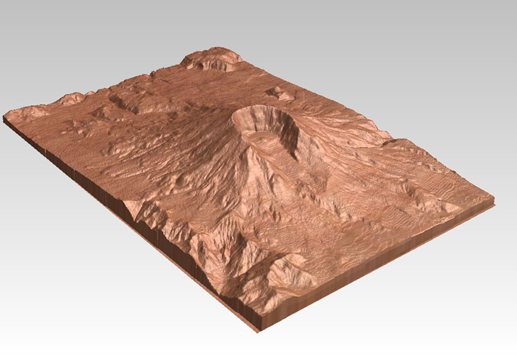
Pikes Peak, Colorado carved by CarvedMaps.com...
Pikes Peak in Colorado has been carved by CarvedMaps.com This company can carve anywhere...

Powderhorn Resort Ski Trail Map
Trail map from Powderhorn Resort, which provides downhill and terrain park skiing. It has 4...

Powderhorn Ski Trail Map
Official ski trail map of Powderhorn Resort ski area from the 2007-2008 season.

Resort Maps of Eagle River Valley Map
Resort Maps of Eagle River Valley is the most popular and widely distributed map of Minturn...

Ridgway State Park Map
Map of park with detail of recreation zones

Rocky Mountain National Park Map
Rocky Mountain National Park Map and surrounding National Forests of Arapaho and Roosevelt.

Rocky Mountain National Park Official Map
Rocky Mountain National Park Official Map. Shows all roads, trails, rivers, and mountain...


Roxborough State Park Map
Map of park with detail of recreation zones

San Juan Mountains Trail Map

San Luis Valley Tourist Map
Tourist map of San Luis Valley, Colorado area. Shows attractions.
Sand Creek Regional Greenway Map
While the Sand Creek Regional Greenway trail is now usable, the Greenway will be under...
