Edit this map

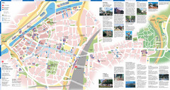
Xanten Tourist Map

near Xanten, Germany

View LocationView Map

51.6621744367752 6.45313739776611 15 satellite
Nearest Map »  Fullsize
1600 × 1096409 KBJPG

Xanten center tourist map

From lh4.ggpht.com

MapAddict added
Feb 6, 2011

Rating
no ratings

See an error? Report it.

Keywords

tourism, town, street map, city, tourist map

0 Comments

New comments have been temporarily disabled.
.
See more

Nearby Maps

Kevelear Tourist Map

Kevelear Tourist Map

Tourist map of Kevelear

10 miles away

Near Kevelear, Germany
Keywords: tourism, city, downtown
Moers City Map

Moers City Map

City street map of Moers

16 miles away

Near Moers, Germany
Kessel Tourist Map

Kessel Tourist Map

Tourist map of Kessel city center

17 miles away

Near Kessel, Germany
Keywords: tourism, city, downtown
Duisburg City Map

Duisburg City Map

Street map of Duisburg center

21 miles away

Near Duisburg, Germany
Duisburg Tourist Map

Duisburg Tourist Map

Tourist map of central Duisburg, Germany. Shows points of interest.

21 miles away

rated 3.75 by 4 people
Near Duisburg, Germany
Krefeld Map

Krefeld Map

Street map of Krefeld

23 miles away

Near Krefeld, Germany
See more