Edit this map

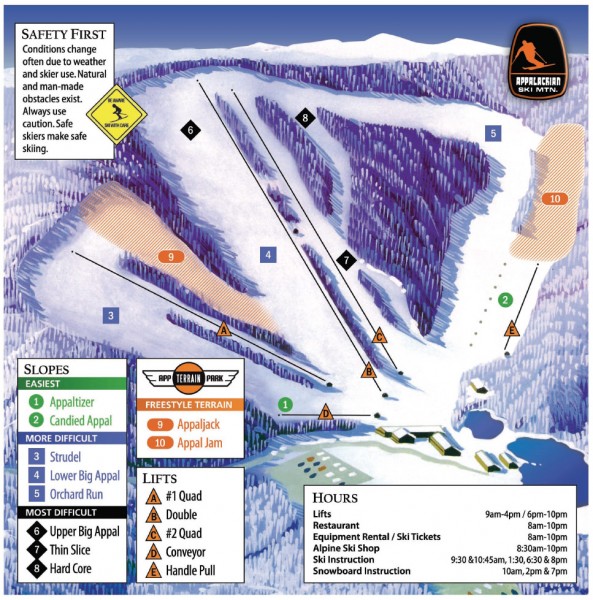
Appalachian Ski Trail Map

near 940 Ski Mountain Road, Blowing Rock, NC 28605

View LocationView Map

36.1727160415041 -81.6615915298462 16 satellite
Nearest Map »  Fullsize
967 × 979317 KBJPG

Official ski trail map of Appalachian ski area

From appskimtn.com

scott added
Dec 5, 2007

Rating
no ratings

See an error? Report it.

Keywords

recreation, skiing, ski area, downhill

0 Comments

New comments have been temporarily disabled.
See more

Nearby Maps

Appalachian Ski Mtn. Ski Trail Map

Appalachian Ski Mtn. Ski Trail Map

Trail map from Appalachian Ski Mtn..

less than 1 mile away

Near Blowing Rock, North Carolina, United States
Tweetsie Railroad Park Map

Tweetsie Railroad Park Map

Tweetsie Railroad is a unique attraction that allows children and families to explore their...

less than 1 mile away

Near Tweetsie Railroad Lane,Blowing Rock, N.C., USA

Keywords: recreation
Watauga County Restaurants Map

Watauga County Restaurants Map

Watuaga County Restaurant Guide

2 miles away

rated 5 by 1 person
Near Boone, NC
Keywords: tourism
Watauga County Attractions Map

Watauga County Attractions Map

Watauga County Tourist Attractions

2 miles away

rated 5 by 1 person
Near Boone, NC
Keywords: tourism
Tweetsie Tourist Map

Tweetsie Tourist Map

3 miles away

Near Tweetsie
Appalachian State University Campus Map

Appalachian State University Campus Map

Campus map of Appalachian State University in Boone, NC

3 miles away

rated 2 by 4 people
Near Boone, NC 28608
See more