Edit this map

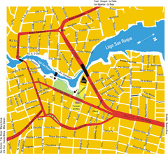
La Falda Map

near La Falda, Cordoba, Argentina

View LocationView Map

-31.0875359 -64.4837265 15 satellite
Nearest Map »  Fullsize
2064 × 1350928 KBJPG

Street map of city

From www.lafalda.gov.ar

Megan added
Sep 11, 2009

Rating
no ratings

See an error? Report it.

Keywords

reference, city, town, street map

0 Comments

New comments have been temporarily disabled.
See more

Nearby Maps

Huerta Grande Tourist Map

Huerta Grande Tourist Map

Tourist street map

2 miles away

Near Huerta Grande, Cordoba, Argentina
San Marcos Sierras Tourist Map

San Marcos Sierras Tourist Map

Tourist map

23 miles away

Near San Marcos Sierras, Argentina
Villa Carlos Paz Center Map

Villa Carlos Paz Center Map

Map of city center

23 miles away

Near Villa Carlos Paz, Cordoba, Argentina
Cordoba City Map

Cordoba City Map

Clear and descriptive city map.

29 miles away

Near Cordoba, Argentina
Cordoba City Map

Cordoba City Map

Street map of city

29 miles away

rated 3 by 1 person
Near Cordoba, Argentina
Alta Gracia Tourist Map

Alta Gracia Tourist Map

Tourist street map

39 miles away

Near Alta Gracia, Cordoba, Argentina
See more