Edit this map

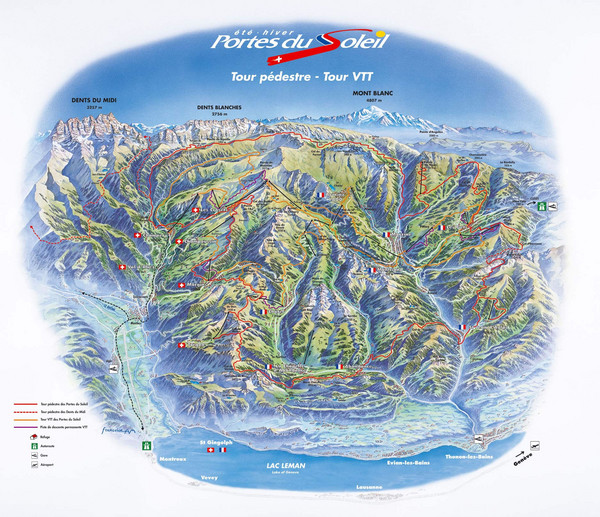
Portes du Soleil Summer Map

near Morzine, France

View LocationView Map

46.1760268245766 6.6192626953125 9 satellite
Nearest Map »  Fullsize
1875 × 1617797 KBJPG

Summer recreation map of the Portes du Soleil covers both the French and Swiss sides of the area, shows footpaths for hikers, and mountain biking runs.

From morznet.com

nicky added
Jun 9, 2008

Rating
rated 4.5 by 2 people

See an error? Report it.

Keywords

tourism, hiking, trails, mountain biking, france, summer, road biking, bikin, cycling

0 Comments

New comments have been temporarily disabled.
.
See more

Nearby Maps

Les Gets Trail Map

Les Gets Trail Map

Mountain biking trail map

3 miles away

Near Les Gets, France
Keywords: recreation
Les Gets Ski Trail Map

Les Gets Ski Trail Map

Trail map from Les Gets.

3 miles away

Near Les Gets, France
Les Gets Ski Resort Map

Les Gets Ski Resort Map

Ski Resort map for Les Gets in France. Map shows runs, lifts, mountains, elevations and amenities.

4 miles away

Near Haute Savoie, France
Keywords: tourism
Morzine Ski Trail Map

Morzine Ski Trail Map

Ski trail map of Morzine and surrounding ski areas.

4 miles away

Near Morzine, France
Morzine Trail Map

Morzine Trail Map

Ski trail map

4 miles away

Near Morzine, France
Keywords: recreation
Morzine Morzine Ski Trail Map

Morzine Morzine Ski Trail Map

Trail map from Morzine.

4 miles away

Near Morzine, France
See more